Maine Snowmobile Association interactive trail map
Statewide Maine snowmobile trail network
Explore the statewide map and check MSA and local clubs for the latest trail information before riding.
Maine Snowmobile Association.

Browse statewide snowmobile maps for Maine, New Hampshire and Vermont, plus local club maps by area. Open maps from the associations, clubs and publishers to help plan your next ride.
Maps are references, not current trail-opening reports. Check the club’s latest notices and landowner restrictions before riding.
Statewide Maine snowmobile trail network
Explore the statewide map and check MSA and local clubs for the latest trail information before riding.
Maine Snowmobile Association.
Statewide New Hampshire snowmobile trail network
Open the official statewide map for trail information and trip planning. Check local clubs for the latest notices before riding.
New Hampshire Snowmobile Association.
Statewide Vermont snowmobile trail network
Open the official statewide map for trail information and trip planning. Check local clubs for the latest notices before riding.
Vermont Association of Snow Travelers; map provided through TrailIntel.
Mount Chase, Shin Pond and the Katahdin area
2024 map
Bowlin Matagamon Shin Pond Snowmobile Club; cartography credited to Northern Geomantics.
Dover-Foxcroft and Sebec Lake
Edition not shown. PDF and image offer the same map artwork.
Piscataquis Valley Snowmobile Club.
Washburn area
Edition date not stated.
The publisher describes the routes as approximate and says the map is not for navigation. Check current club notices before riding.
Linked by Washburn Trail Runners; hosted by Google Maps.
Danforth and Weston area
2025–2026 trail map.
Older-season map with plowed-road and logging annotations. Confirm later changes and access with the club; mapped businesses and parking do not establish current availability.
East Grand Snowmobile Club.
Katahdin region, including Big Valley Sno-Club’s network
2026 regional map.
Regional coverage names several clubs separately; it is not a complete local Big Valley map. Check the responsible club’s dated notices for route changes and current access; service and parking symbols do not establish present availability.
Katahdin Area Snowmobile Trails; Big Valley Sno-Club profile provides local context.
Aroostook County and northern Maine connections
Viewer labelled 2026–2027.
The publisher notes that junctions may move during the season. Check the responsible club for current routes and access.
Association of Aroostook Chamber of Commerce Executives; linked by Caribou Snowmobile Club.
Kokadjo and the Moosehead Lake region
Map edition not shown.
The club page displays a Google My Maps viewer. Check the club’s dated trail notices before riding; the map does not confirm current access.
Kokadjo Roach Riders Snowmobile Club; Google My Maps. Club information.
Coburn Mountain and The Forks area
Printed edition not shown. Source filename includes 2020.
Coburn Summit Riders.
The Forks and surrounding trail connections
Printed edition not shown. The file and PDF metadata refer to 2026.
Map published by Northern Outdoors for the Forks area.
Jackman and Dennistown region
Printed edition not shown; URL and PDF metadata refer to February 2026.
Logging-road, off-trail and adjoining-network accuracy notices apply. Confirm later changes with the responsible clubs; mapped routes do not establish current access.
Border Riders Sportsman’s Club.
Winslow, Maine
Printed map: 2007–2008.
This older map is background information. Its notes say trail locations and conditions can change and trails end at the water’s edge. Check the club for the applicable map and current access before planning a ride.
Fort Halifax Snowdrifters map, preserved in the Town of Winslow comprehensive plan. Club information.
Solon and nearby connections
2017–2018 map; two-page PDF.
This older map includes historical route and service information. Confirm current routes, parking and access with the club before riding.
Solon Snow Hawks Snowmobile Club. Club information.
Newburgh and surrounding local trails
Map dated March 19, 2026.
Newburgh Countryside Riders; map credits the Off-Road Vehicle Program.
Smithfield and adjoining club trails
Web map update label: September 7, 2025. GPS file metadata is dated February 1, 2023.
Smithfield Moonshiners; supplied GPS file includes GeoTracker attribution.
Hampden, Maine
Map updated November 9, 2016.
This older map is for reference use only. Its legend separates club trails, ITS 82 and trails not GPS verified. Check current club notices before riding; old clubhouse and fuel symbols do not confirm present access or services.
Goodwill Riders map by Kyle Severance, hosted by the Town of Hampden. Club information.
Parkman and nearby connections
2016–2017 Trail Map.
This older map includes historical route markings. Confirm current routes and access with the club before riding.
Parkman Trailblazers Snowmobile Club; hosted by the Town of Parkman. Club information.
Calais, Baring, Meddybemps, Charlotte and Red Beach
Map edition not shown. Publisher page dated October 12, 2021.
The publisher provides a map image; a separate PDF requires contacting the club. Treat crossing and service labels as historical information and confirm current routes and access before riding.
Sunrise Snowmobilers; hosted by the Maine Snowmobile Association. Club information.
New Vineyard, New Portland and Porter Lake
Edition not shown; two satellite map panels at the source.
New Vineyard North Snowmobile Club.
Salem, Freeman Township and nearby trails
2023–2024 map.
Salem Sno Drifters.
Gilead, West Bethel and Bethel area
Printed editions not shown. Source files labelled 2023 and 2022 have different extents.
Wild River Riders.
Rumford and the wider River Valley
2026 maps.
The local map and wider River Valley map have different coverage. Check the club’s latest route and parking notices before riding.
Rumford Polar Bears Snowmobile Club.
Dixfield and nearby connections
Edition not shown.
The club hosts this local map without a stated edition. Confirm current routes and access with the club before riding.
Dixfield-Poodunck Snowmobile Club. Club information.
Oxford; Smith Bridge Preserve
Edition not shown.
This preserve map marks a designated snowmobile trail; it covers part of the local area. The land trust names Rock-o-Dundee as the maintainer. Confirm current routes and access before riding.
Western Foothills Land Trust. Club information.
North Yarmouth, Pownal and Yarmouth area
Map dated February 16, 2025.
Rocky Coast Riders Snowmobile Club.
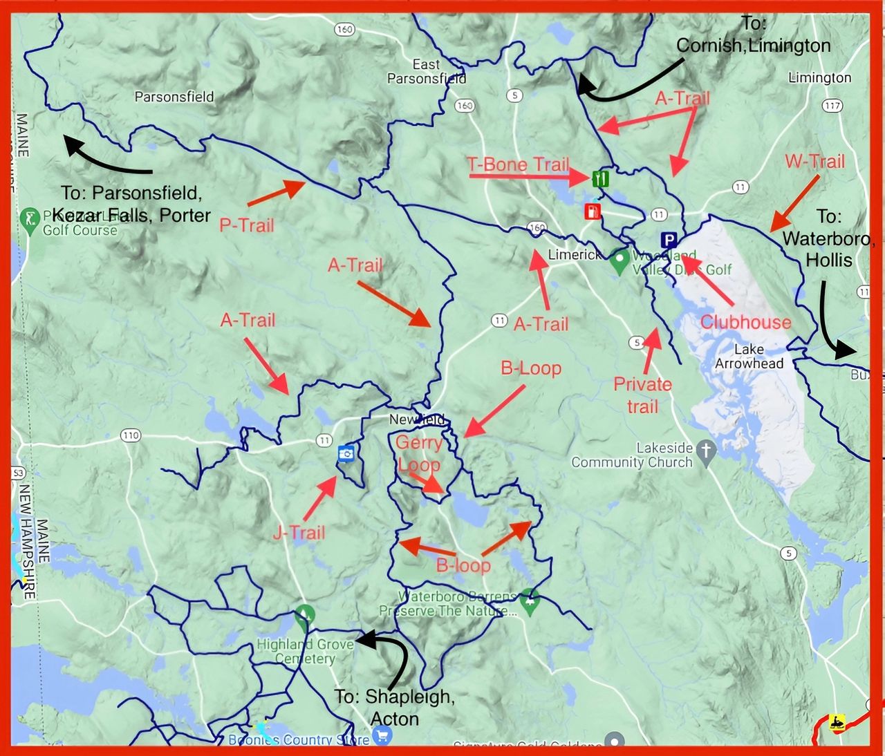
Limerick and Newfield
Edition not shown.
Rt. 11 Streakers Snowmobile Club.
Alfred and adjoining local trails
2025–2026 season; March 1, 2026 printed on the map.
Shaker Valley Sno Travelers.
Topsham trail system
2026 map and information guide.
Follow the map’s separate ATV-only, mixed-use and snowmobile-only markings, width limits and printed warnings.
Topsham Trailriders.
Westbrook trail system
Printed edition not stated; filename includes Updated 2025.
The map is not to scale and shows general trail and business locations. Follow its activity markings and check current club notices before riding.
Westbrook Trail Blazes; printing credited to XPress Copy.
Alexandria and the Newfound area
2026 map.
The legend distinguishes local, primary, corridor, unmaintained and neighboring trails. Confirm current changes with the club.
Alexandria Ledge Climbers Snowmobile Club.
Warren, Glencliff and local loop trails
Printed edition not shown.
Regional base map with local loop overlays. Check current reroutes with the club.
Asquamchumauke Valley Snowmobile Club map resource.
Rumney and Ellsworth area
Printed map enquiries; edition not shown.
Ask the club about the applicable printed map and availability.
Bruhawachet Sno-Trackers.
Wentworth, Baker River Valley and nearby trails
Printed-map enquiries; edition not shown.
The club lists maps at its clubhouse and local stockists. Confirm the recommended edition, opening arrangements and availability before travelling.
Baker River Valley Snowmobile Club.
Bridgewater Mountains and the Newfound Lake region
2020–2021 trail map.
Use this older map with the club’s latest notices. Parking symbols, connection lines and sponsor advertisements do not confirm current access, services or availability.
Bridgewater Mountain Snowmobile Club; map credits GPS Trailmasters and Google.
Hebron, Groton and northern Newfound Lake
HCSC Groomer Map; printed edition not shown.
The colored routes are map references, not a live grooming report. Ask the club which later reroute notices apply, including its dated Hobart Hill work report.
Hardy Country Snowmobile Club; map includes nhtopo11 and MapSetToolKit credits.
Canaan, Cardigan-area trails and statewide connections
Statewide map information; no fixed printed edition.
The club links to the SledNH map resource. Read the dates on local trail reports and confirm changes and access for your intended route.
Mt. Cardigan Snowmobile Club; map information provided by SledNH.
Grantham and surrounding Upper Valley trails
Older map; printed edition not shown.
The 600 × 927 image is a historical reference with limited detail. Ask the club for current trail information.
Blue Mountain Snow Dusters; older Northeast Snow map resource.
North Haverhill and nearby trail connections
Printed edition not shown.
The 305 × 407 map image has limited detail. Check the club’s current notices rather than treating the older map or trail report as an opening notice.
Connecticut Valley Snowmobile Club.
Plainfield, Cornish and neighboring Upper Valley connections
Club page labels the map 2022; no printed edition shown on the map.
The legend separates club, secondary, Corridor 5 and neighboring trails. Respect private property and stay on marked trails; check the club for later changes.
Blow-Me-Down Snowriders.
Sugar River Recreational Rail Trail: Newport to Claremont
State rail-trail map; printed edition not shown.
Regional rail-trail reference associated with Shugah Valley’s maintenance area, rather than its entire club network. Parking symbols do not confirm current trailer access or winter availability.
New Hampshire State Parks / Bureau of Trails.
Unity, Acworth and surrounding local connections
2026–2027 map; revised September 24, 2026.
The legend distinguishes corridor, primary, club and closed trails. Check later notices; the map’s dated closure labels do not establish today’s conditions. Small labels have limited detail.
Crescent Lake Regional Sno-Riders; basemap credits ExpertGPS, Mapbox and OpenStreetMap.
Lisbon, Ammonoosuc Rail Trail and neighboring connections
Printed-map enquiries; edition not shown.
The club identifies a Lisbon map retailer. Confirm the recommended edition and availability with the club before travelling; older prices and reports may have changed.
Lisbon Stump Jumpers.
Charlestown and statewide snowmobile planning
NHSA interactive map; no fixed printed edition.
The club links the statewide interactive map for snowmobile planning. Check local notices and permissions; range membership and range access are separate.
Old #4 Sportsmen Club; interactive map provided by NHSA.
Milton and the Moose Mountains area
Printed map outlet page; edition not shown.
Ask the club about the map’s edition and current availability.
Evergreen Valley Snowmobile Club.
Newmarket, Newfields and Lee area
Interactive source; no fixed printed edition.
The club links to the statewide SLEDNH map and describes its local network. Check the provider and club for current trail conditions.
Great Bay Sno-Rollers; statewide map provided by SLEDNH.
Pelham local trail area
Printed edition not shown.
The 677 × 517 image has small labels and no visible legend or scale. Colored marks and parking symbols are not current access or parking permission.
Border Riders of Pelham; club town-map page.
Newfields and nearby local trails
Club image filename includes 2026; printed edition not verified.
The supplied image shows a small partial regional view without a complete legend or scale. Check the club map and dated reports together.
Newfields Sno-Raiders.
Strafford and neighboring local connections
Older 400 × 258 map image; printed edition not verified.
Small labels have limited detail. The image shows historic trails and service symbols; confirm current routes and access with the club.
Strafford Swamp Stompers; older Northeast Snow map reference.
Kingston local trails and regional map references
Kingston town-trails PDF: 2020/2021 season.
The club labels its reference maps as not for actual travel: they are not to scale, and trails may have closed or changed. Check the applicable edition and current route with the club.
Southern New Hampshire Trailblazers.
Hollis, Milford and the Tri-Club trail area
Tri-Club printed-map enquiries; edition not shown.
The club lists dealers for the IceBreakers, Nor’Easters and Winter Wanderers regional map. Confirm edition and stock, and check later rail-trail, orchard and parking restrictions.
Nor’Easters Snowmobile Club; shared Tri-Club map resource.
North and South Uncanoonuc Mountains, Goffstown
Municipal recreation map, published May 2017.
The map distinguishes red-dashed snowmobile trails from black-dashed foot-only trails and a private hikers-only area. Confirm private-land snowmobile permission and winter clearance with the club; parcel boundaries are not authoritative.
GoffstownTrails.com; municipal recreation map, not a club-authored network map.
Wilton, Lyndeborough and shared Tri-Club map area
Tri-Club paper-map enquiries; edition not shown.
The club lists retailers for the shared Tri-Club map. Confirm edition and stock, and check later rail-trail, orchard and parking restrictions before planning a ride.
Wilton/Lyndeborough Winter Wanderers; shared Tri-Club map resource.
Ashuelot Recreational Rail Trail near Hinsdale
Historical construction map: expected completion December 15, 2025.
This is a state construction-location reference, not the Keene club’s complete trail map. The stated completion estimate does not establish whether work is finished or the trail is open.
New Hampshire State Parks; dated Ashuelot construction reference.
Walpole and neighboring trail connections
Older source image: 2008–2009. Club map page also displayed a 2014–2015 map.
These are different maps. The older image’s service listings and route markings do not establish current availability or access. Check the club map page for later information.
Hooper Hill Hoppers.
Westmoreland and local connections
Club map page; printed edition not verified.
Use the club’s map page for its recommended local map and dated reports. The older download filename is not a verified edition; confirm current routes and permissions.
Westmoreland Sno-Belters.
Winchester, Pisgah State Park and southern connections
Historical map image; printed edition not verified.
Small labels limit detail. The map requires prior written permission for reproduction; use the retained source link and confirm current routes, parking and access separately.
Winchester Trailriders; retained Northeast Snow image reference.
Chesterfield and regional trail connections
Regional interactive map resource; no fixed printed edition.
The club’s own page links this regional SledNH view. Check current local notices and permissions before planning a connection.
Chesterfield Snowmobilers; regional map provided by SledNH.
Ashuelot Recreational Rail Trail construction context
Historical construction map; expected completion December 15, 2025.
This state map locates earlier construction work. It does not establish present closures or reopening, ATV permission, or the full Pisgah trail network. Check the state page and club for later notices.
NH State Parks; separate rail-trail management context.
Moultonborough, Center Harbor and the Ossipee Mountains
2024 map; copyright January 2024.
The legend distinguishes corridor, primary, local, service and water passages. Water crossings are not groomed, marked or tested; check current club notices before riding.
Moultonboro Snowmobile Club; map credits OpenStreetMap, Mapbox, Bill Gassman and JustHitPrint.net.
Tamworth, Ossipee, Sandwich and Effingham
Club page says its fold-out map was last printed for 2020–2021.
Ask the club about the applicable printed map and later changes. A print offer does not establish current stock, prices or trail access.
Ossipee Valley Snowmobile Club.
Wakefield and nearby lake-area trails
Printed map enquiries; edition not shown.
The club recommends a full-size local map and warns that groomed trails do not establish safe lake ice. Check current signs and access restrictions before riding.
Seven Lakes Snowmobile Club.
Meredith and surrounding Lakes Region connections
Interactive map resource; no fixed printed edition.
The club directs visitors to the statewide SLEDNH map. Check the provider and club’s dated notices for current conditions and local changes.
Sno-Streakers; statewide map provided by SLEDNH.
Pemi Oxbow Preserve: Plymouth, Holderness and Ashland
Preserve map produced August 2024; story published Fall/Winter 2024.
The preserve illustration distinguishes snowmobile trails from hiking/biking trails. It covers this conservation property, rather than the club’s full network; check current local access.
Squam Lakes Conservation Society; map data credited to GRANIT.
Gilmanton and statewide corridor connections
Statewide interactive map resource; no fixed printed edition.
The club links to the SledNH corridor-map service. Confirm local changes and access with the club and read the date of any condition report.
Gilmanton Snowmobile Association; statewide map provided by SledNH.
Mount Washington Valley and Conway
Snowmobile Trails 2026.
The map distinguishes main, club and proposed trails. Proposed lines do not establish completed connections. The supplied image is 892 × 1190 pixels, so small labels have limited detail.
Mountain Meadow Riders Snowmobile Club.
Jefferson, Randolph and neighboring White Mountains trails
One map printed 2022; a separate older map has no printed edition.
The maps have different extents. Follow their club, corridor, connecting and closed-trail legends; old closure labels do not establish current conditions. Groomers have the right of way.
Jefferson Hi-Landers; design and printing credited to Smith & Town Printers LLC.
Madison and surrounding local trails
Club page describes maps updated for the 2024–2026 seasons.
The club lists printed-map vendors. Confirm the applicable edition and availability directly; no downloadable local map was offered on the saved page.
Scrub Oak Scramblers.
Berlin and Coos County regional planning resources
Scenic-view and fuel sheets: February 3–5, 2012 ride-in.
These historical sheets contain old directions, distances and fuel hours. The club describes later routing changes and newer paper maps; ask which edition to use before planning a ride.
Scenic sheet: White Mountain Ridge Runners. Fuel sheet: Presidential Range Riders; both hosted by WMRR.
Bartlett, Albany and Livermore area
Paper and digital map information; edition not shown.
Confirm the map edition, availability and delivery arrangements with the club. Product listings do not establish current trail routes or activity-specific permission.
White Mountain Trail Club.
Andover and nearby central New Hampshire trails
Older club map-page reference; check the edition with the club.
Use the club’s map page and confirm later reroutes and current trail conditions.
Andover Snowmobile Club.
Henniker and surrounding connections
Older map; printed edition not shown.
The sketch shows neighboring connections and park-and-ride labels, with no visible scale or detailed legend. Use it as a historical reference and confirm current access.
Henniker Trail Travelers; map credited to NHFE.
Loudon, Canterbury and nearby connections
Club page labels the download 2011; no printed edition visible in the image.
The supplied photograph shows only part of a map, with soft labels and no complete legend or scale. Ask the club about its newer printed map and current routes.
New Hampshire Sno-Shakers.
Barnstead, Pittsfield and neighboring connections
7th edition, February 2026; printed February 28, 2026.
The club’s public folder includes its map and a dated use guide. Maps do not show current trail status; closed gates, seasonal permissions and actual conditions still need checking.
Suncook Valley Sno-Riders; cartography by Brian Lamarsh, with credited source data.
Sutton and nearby trail connections
Club map-resource page; no fixed edition shown.
The club directs riders to the NHSA map resource. Respect private landowner restrictions and check current signs and local notices.
Sutton Ridgerunners.
Boscawen and neighboring local trails
Embedded interactive map; edition not shown.
Open the map through the club’s page or its embedded provider. The page’s undated gates/trails-closed labels do not establish today’s conditions.
Town Line Trail Dusters; embedded Google My Maps resource.
Bow, Dunbarton, Concord and Hopkinton
2022–2023 trail map.
The legend separates snowmobile trails from routes not maintained by the club. Respect the printed use and time restrictions, and check the club for later changes and current access.
Bow Pioneers Snowmobile Club.
Lake Sunapee and nearby central New Hampshire trails
NHSA online map resource; no fixed printed edition.
The club’s FAQ directs riders to the NHSA map and says it no longer publishes a paper map. Check the provider and club for later local changes and dated reports.
Lake Sunapee Snowmobile Club; map information provided by SledNH.
Stratford and surrounding North Country trails
Club map-request resource; edition not shown.
Use the club’s trail page to enquire about a map. Undated trail-status headings and sample groomer updates do not establish current conditions.
Stratford Nighthawks Snowmobile Club.
Milan, Berlin, Errol and northern Coos corridor context
Printed edition not shown; cropped regional overview.
The small image lacks a complete legend and scale. Ask the club which current local map covers reroutes; the overview and its parking symbols do not establish present access.
Milan All Weather Riders hosts the overview; underlying map credit is not visible in the supplied crop.
Gorham and White Mountains trail-map enquiries
Local paper-map enquiries and SledNH map information; edition not shown.
The club’s FAQ describes local paper maps and the SledNH resource. Confirm the recommended edition and availability, and check dated local conditions before travelling.
Presidential Range Riders; statewide map information provided by SledNH.
Diamond Pond and Swift Diamond trail-map enquiries
Club map enquiries; edition not shown.
The club’s warming-hut page lists maps among its merchandise. Confirm current edition, stock and opening arrangements directly; the listing does not guarantee fuel, parking or present trail access.
Swift Diamond Riders.
Presidential Rail Trail: Randolph and Corridor 12 crossing context
State flagger-location map; February 18, 2026 filename, printed edition not shown.
The state-hosted annotated map view locates work crossings near Randolph. It does not establish current flagger deployment, closures, hiking-trailhead snowmobile parking permission or a complete Whitefield club network.
NH State Parks hosts the work map; the underlying view names Presidential Range Riders and carries a TrakMaps mark.
Island Pond, Vermont
Brighton’s official trail-map page displays the Essex County Vermont Snowmobile Map, marked 2025–2026. This county map includes the Island Pond area and neighboring trail systems; its coverage extends beyond Brighton. The printed season does not establish current trail conditions. A 2026–2027 edition was not verified. Check VAST’s interactive map and the club’s dated notices for closures and reroutes.
Open the Vermont statewide interactive trail map. Check current closures and reroutes before riding.
Derby, Vermont
Drift Dusters’ paper-map listing is a statewide VAST product, labeled 2025 and described for 2025–2026. Its product photograph shows covers marked 2022–2024. Confirm the actual edition and availability with the publisher; these conflicting dates do not establish a current local club-map edition. The club’s trail-report page also links map resources.
The page mixes dated notices and an older ratings table; check each timestamp. Use VAST’s statewide interactive map and the club’s latest notices for trip planning.
Lyndonville, Vermont
The VAST-linked club Facebook address now opens the Lyndon Sno-Cruisers’ public updates. Check each announcement’s date for local trail notices. Use VAST’s map information and the Vermont statewide interactive trail map for route planning.
A separate current local map was not verified: the club website did not return a usable response during this review. Ask the club through its VAST listing about local map availability and check dated trail notices before riding.
Canaan, Vermont
For an additional regional reference, Brighton Snowmobile Club’s official map page displays an Essex County map marked 2025–2026. A Canaan-specific map edition and a 2026–2027 replacement remain unverified. Confirm current local routes and any cross-border access with VAST and the club.
A current club-specific downloadable map was not verified. Use VAST’s Vermont interactive trail map and the club’s dated notices to plan a route. Connections toward another state or Canada do not establish current access.
Burke area, Vermont
A separate current local-map edition was not verified. Start with VAST’s statewide interactive trail map, then check the club’s dated notices for local closures and reroutes.
Walden area, Vermont
A separate current Coles Pond Sledders map was not verified. Use VAST’s Vermont interactive trail map and ask the club about current local map availability, reroutes and access.
Guildhall, Vermont
For historical context, Guildhall’s plan adopted July 25, 2024 reproduces a local VAST map labeled 2024 (PDF page 16), beside the Connecticut Valley Sno-Riders identification logo. Treat this as a dated local snapshot; its route colors do not establish present trail conditions. A current complete club-map edition remains unverified.
A current downloadable club-map edition was not verified. Use VAST’s statewide interactive trail map and the club’s dated notices for trip planning.
Peacham, Vermont
A current club-specific downloadable map was not verified. Use VAST’s statewide interactive trail map and the club’s dated notices for current route planning and local closures.
Groton, Vermont
Cross Vermont Trail Association hosts a November 13, 2025 project report with a reproduction of the Buckaroos’ Groton snowmobile trail map (PDF page 2). The report date is not a verified edition date for the map itself. A standalone map original and current trail access remain unverified.
The club’s trail-map and conditions button links to VAST’s statewide map application. A separate downloadable local edition was not established.
For the current association-linked destination, open VAST’s Vermont interactive trail map and check dated club notices before riding.
St. Johnsbury, Vermont
Check the club’s public trail notices alongside the statewide map for dated local updates and reroutes. This public club page does not establish a separate local-map edition or permission to ride.
A current club-specific downloadable map was not verified. Use VAST’s statewide interactive trail map and the club’s dated notices for current route planning and local closures.
Troy, Vermont
The club’s VAST Trail Map & Conditions page embeds the statewide map with a Country Riders filter. It does not establish a separate downloadable local-map edition.
Also see VAST’s currently linked statewide map. Check each report’s date and follow current local notices.
Craftsbury, Vermont
The local trail committee’s Craftsbury snowmobiling guide points riders to VAST’s digital map and the Snow Chargers’ public updates. The guide’s 2022 listing date is not a club-map edition or current access notice. A separate dated map of the club’s complete snowmobile network remains unverified.
A current club-specific downloadable map was not verified. Use VAST’s statewide interactive trail map and the club’s dated notices for current route planning and local closures.
Danville, Vermont
See the club’s public updates for dated local information alongside the VAST map. This public page is linked by VAST and the statewide map provider; its photo albums did not establish a separate dated club-map edition. Check the date of each notice before planning a ride.
A current club-specific downloadable map was not verified. Use VAST’s statewide interactive trail map and the club’s dated notices for current route planning and local closures.
Glover, Vermont
Glover Trailwinders’ official map page embeds the “Glover Trails” map. Its Google My Maps viewer displays a publication date of October 20, 2021. That is a publication date, not a verified latest-update date or current map edition. Confirm route and service changes with the club before traveling.
Check the club’s dated trail notices and VAST’s statewide map for current planning. The club map is a reference, not a trail-opening report.
Hardwick, Vermont
A separate current downloadable local-map edition was not verified. Use VAST’s Vermont interactive trail map and the club’s dated notices for route planning and current local closures.
Lowell, Vermont
A separate current downloadable local-map edition was not verified. Use VAST’s Vermont interactive trail map and the club’s dated notices for route planning and current local closures.
Lunenburg, Vermont
For historical context, page 14 of the Lunenburg Town Plan adopted February 5, 2024 reproduces a VAST snowmobile-trail snapshot and describes the Polar Bears’ trail work. The separate adjacent map is an ATV map. This planning document is not a current complete club-map edition or trail-condition report.
Use VAST’s current Vermont interactive map and the club’s dated notices before riding.
Granby, Vermont
The club’s Trail Conditions page links to a Moose River Rock Dodgers map file titled “MRRD trails 23-24”. The image carries a 2022 printer credit and includes neighboring trail labels. It is a historical map excerpt, not a verified current complete club-map edition or trail-condition report. Check the club’s dated trail notices before traveling.
For wider planning use VAST’s Vermont interactive trail map. No current downloadable club-map original was established.
Newark, Vermont
The club website links VAST’s statewide map. Use VAST’s current Vermont interactive map and the club’s dated public updates when planning a route. A separate downloadable Newark map edition was not verified.
Newport Center, Vermont
A separate downloadable local trail-map edition was not verified in the reviewed club sources. Use VAST’s official Vermont interactive trail map and check the club’s dated notices for local closures and reroutes.
Map coverage and nearby weather do not establish that a trail is open. Confirm local map availability and access arrangements with the club.
Norton, Vermont
A separate downloadable local trail-map edition was not verified in the reviewed club sources. Use VAST’s official Vermont interactive trail map and check the club’s dated notices for local closures and reroutes.
Map coverage and nearby weather do not establish that a trail is open. Confirm local map availability and access arrangements with the club.
Orleans (Barton), Vermont
A separate downloadable local trail-map edition was not verified in the reviewed club sources. Use VAST’s official Vermont interactive trail map and check the club’s dated notices for local closures and reroutes.
Map coverage and nearby weather do not establish that a trail is open. Confirm local map availability and access arrangements with the club.
St. Johnsbury, Vermont
A separate downloadable local trail-map edition was not verified in the reviewed club sources. Use VAST’s official Vermont interactive trail map and check the club’s dated notices for local closures and reroutes.
Map coverage and nearby weather do not establish that a trail is open. Confirm local map availability and access arrangements with the club.
Waterford, Vermont
A separate downloadable local trail-map edition was not verified in the reviewed club sources. Use VAST’s official Vermont interactive trail map and check the club’s dated notices for local closures and reroutes.
Map coverage and nearby weather do not establish that a trail is open. Confirm local map availability and access arrangements with the club.
Wheelock, Vermont
A separate downloadable local trail-map edition was not verified in the reviewed club sources. Use VAST’s official Vermont interactive trail map and check the club’s dated notices for local closures and reroutes.
Map coverage and nearby weather do not establish that a trail is open. Confirm local map availability and access arrangements with the club.
Alburgh, Vermont
A separate downloadable local trail-map edition was not verified in the reviewed club sources. Use VAST’s official Vermont interactive trail map and the club’s dated notices for local closures and reroutes.
Confirm local map availability with the club. A map reference or nearby weather forecast does not establish open trails or permission to ride.
Enosburgh area, Vermont
The Missisquoi Valley Rail Trail publisher provides regional rail-trail maps, including Richford and nearby VAST connections. Its winter-recreation page identifies Cold Hollow Bearcats and Northwest Riders as local grooming clubs. These maps cover the rail trail and its surroundings; a printed edition date and a map covering the Bearcats’ complete network were not verified. Confirm current winter access with VAST and the club.
A separate downloadable local trail-map edition was not verified in the reviewed club sources. Use VAST’s official Vermont interactive trail map and the club’s dated notices for local closures and reroutes.
Confirm local map availability with the club. A map reference or nearby weather forecast does not establish open trails or permission to ride.
Fletcher, Vermont
The club’s VAST listing says the Fletcher General Store sells VAST maps. That information is undated; confirm stock and map edition with the seller.
For wider route planning, use VAST’s official Vermont interactive map and the club’s dated updates. A separate downloadable local-map original was not established.
Georgia area, Vermont
A separate downloadable local trail-map edition was not verified in the reviewed club sources. Use VAST’s official Vermont interactive trail map and the club’s dated notices for local closures and reroutes.
Confirm local map availability with the club. A map reference or nearby weather forecast does not establish open trails or permission to ride.
Eden, Vermont
A separate downloadable local trail-map edition was not verified in the reviewed club sources. Use VAST’s official Vermont interactive trail map and the club’s dated notices for route planning, closures and reroutes.
Confirm local map availability with the club. A map reference or nearby area forecast does not establish trail access or open conditions.
Hinesburg, Vermont
The club publishes individual map notices, including a Lincoln Hill Road work-warning image displayed as February 23 on Facebook; its year was not shown in the reviewed view. This is a partial route snapshot, not a complete club map or confirmation that the work notice remains in effect. Check the club’s latest public updates and VAST’s official Vermont interactive trail map before traveling.
Confirm local map availability with the club. A map reference or nearby area forecast does not establish trail access or open conditions.
Colchester, Vermont
A separate downloadable local trail-map edition was not verified in the reviewed club sources. Use VAST’s official Vermont interactive trail map and the club’s dated notices for route planning, closures and reroutes.
Confirm local map availability with the club. A map reference or nearby area forecast does not establish trail access or open conditions.
Sheldon meeting locality, Vermont
A separate downloadable local trail-map edition was not verified in the reviewed club sources. Use VAST’s official Vermont interactive trail map and the club’s dated notices for route planning, closures and reroutes.
Confirm local map availability with the club. A map reference or nearby area forecast does not establish trail access or open conditions.
Ferrisburgh contact locality, Vermont
A separate downloadable local trail-map edition was not verified in the reviewed club sources. Use VAST’s official Vermont interactive trail map and the club’s dated notices for route planning, closures and reroutes.
Confirm local map availability with the club. A map reference or nearby area forecast does not establish trail access or open conditions.
Essex, Vermont
A Saxon Hill Riders letter dated January 4, 2026, included on PDF page 12 of Westford’s January 8 meeting packet, discusses a change to the Westford Common spur on the VAST map for the 2025–26 season. This is a dated local planning notice, not a complete club-map edition or present trail-status report. Check VAST’s Vermont interactive map and the latest club notices before traveling.
Confirm local map availability with the club. Map coverage and nearby area weather do not establish open trails, parking or permission to ride.
Jeffersonville (Cambridge), Vermont
The club’s February 6, 2020 trail notice and annotated map describe a Bakersfield-to-Eden connection via trail 108N. This is a historical, single-route reference; a current complete club-map edition and present access remain unverified. Check VAST’s Vermont interactive map and the latest club notices before traveling.
Confirm local map availability with the club. Map coverage and nearby area weather do not establish open trails, parking or permission to ride.
Morrisville (Morristown), Vermont
A separate downloadable local trail-map edition was not verified in the reviewed club sources. Use VAST’s official Vermont interactive trail map and the club’s dated notices for closures and reroutes.
Confirm local map availability with the club. Map coverage and nearby area weather do not establish open trails, parking or permission to ride.
Johnson, Vermont
A separate downloadable local trail-map edition was not verified in the reviewed club sources. Use VAST’s official Vermont interactive trail map and the club’s dated notices for closures and reroutes.
Confirm local map availability with the club. Map coverage and nearby area weather do not establish open trails, parking or permission to ride.
Stowe, Vermont
The Town of Stowe’s Sterling Forest management plan, adopted February 12, 2025, includes a map of the forest’s VAST corridor (PDF page 8) and discusses the Stowe Snowmobile Club’s trail role (page 21). This covers one forest area; a separate map revision date and a current complete club-map edition remain unverified. Check VAST’s Vermont interactive map and current club notices for trip planning.
A separate downloadable club-map edition was not established. The FAQ’s business and route information does not itself confirm current access or trail conditions.
Williston, Vermont
A separate downloadable local trail-map edition was not verified in the reviewed club sources. Use VAST’s official Vermont interactive trail map and the club’s dated notices for closures and reroutes.
Confirm local map availability with the club. Map coverage and nearby area weather do not establish open trails, parking or permission to ride.
South Barre (Barre town), Vermont
For historical context, the Town of Barre’s forest plan includes an access and recreation map dated March 25, 2013 (PDF page 169). It shows snowmobile trails within Barre Town Forest; the plan identifies the Thunder Chickens as their local managers. The map is by The Trust for Public Land, with trail information from Millstone Trail Association. This historical planning map covers the forest only and does not establish current routes, parking or permission to ride.
A current map covering the club’s full trail network was not verified in the reviewed sources. Use VAST’s official Vermont interactive trail map and the club’s dated notices for closures and reroutes.
Confirm local map availability with the club. Map coverage and nearby area weather do not establish open trails, parking or permission to ride.
East Montpelier, Vermont
A separate downloadable local trail-map edition was not verified in the reviewed club sources. Use VAST’s official Vermont interactive trail map and the club’s dated notices for closures and reroutes.
Confirm local map availability with the club. Map coverage and nearby area weather do not establish open trails, parking or permission to ride.
Waterbury, Vermont
A separate downloadable local trail-map edition was not verified in the reviewed club sources. Use VAST’s official Vermont interactive trail map and the club’s dated notices for closures and reroutes.
Confirm local map availability with the club. Map coverage and nearby area weather do not establish open trails, parking or permission to ride.
Waitsfield, Vermont
A separate downloadable local trail-map edition was not verified in the reviewed club sources. Use VAST’s official Vermont interactive trail map and the club’s dated notices for closures and reroutes.
Confirm local map availability with the club. Map coverage and nearby area weather do not establish open trails, parking or permission to ride.
East Calais (Calais), Vermont
A separate downloadable local trail-map edition was not verified in the reviewed club sources. Use VAST’s official Vermont interactive trail map and the club’s dated notices for closures and reroutes.
Confirm local map availability with the club. Map coverage and nearby area weather do not establish open trails, parking or permission to ride.
Barre area, Vermont
Barre City’s 2017–2027 Cow Pasture management plan includes a February 2017 trail map by Emily Brodsky in Appendix 1 (PDF page 43). A November 2022 city packet connects Sno-Bees’ local trail work to this map. It covers the municipal Cow Pasture area, not the complete club network, and does not establish current routes or access. Use VAST’s Vermont interactive map and current club notices when planning a ride.
Confirm local map availability with the club. Map coverage and nearby area weather do not establish open trails, parking or permission to ride.
Marshfield, Cabot and Plainfield, Vermont
Marshfield’s Stranahan Town Forest map, updated May 24, 2019 by CVRPC, shows local forest trails and Thompson Road. The town’s 2022 forest plan identifies Twinfield Snow Travelers’ role along this corridor. This municipal mixed-use map covers only part of the club’s area; it does not establish snowmobile access on every depicted trail, current conditions or a complete club-map edition. Check VAST’s Vermont interactive map and current club notices.
Confirm local map availability with the club. Map coverage and nearby area weather do not establish open trails, parking or permission to ride.
Worcester, Vermont
A separate downloadable local trail-map edition was not verified in the reviewed club sources. Use VAST’s official Vermont interactive trail map and the club’s dated notices for closures and reroutes.
Confirm local map availability with the club. Map coverage and nearby area weather do not establish open trails, parking or permission to ride.
Bridport, Vermont
A separate downloadable local trail-map edition was not verified in the reviewed club sources. Use VAST’s official Vermont interactive trail map and the club’s dated notices for closures and reroutes.
Confirm local map availability with the club. Map coverage and nearby area weather do not establish open trails, parking or permission to ride.
Ferrisburgh, Vermont
A separate downloadable local trail-map edition was not verified in the reviewed club sources. Use VAST’s official Vermont interactive trail map and the club’s dated notices for closures and reroutes.
Confirm local map availability with the club. Map coverage and nearby area weather do not establish open trails, parking or permission to ride.
Middlebury, Vermont
A separate downloadable local trail-map edition was not verified in the reviewed club sources. Use VAST’s official Vermont interactive trail map and the club’s dated notices for closures and reroutes.
Confirm local map availability with the club. Map coverage and nearby area weather do not establish open trails, parking or permission to ride.
Bristol, Vermont
A separate downloadable local trail-map edition was not verified in the reviewed club sources. Use VAST’s official Vermont interactive trail map and the club’s dated notices for closures and reroutes.
Confirm local map availability with the club. Map coverage and nearby area weather do not establish open trails, parking or permission to ride.
Williamstown, Vermont
A separate downloadable local trail-map edition was not verified in the reviewed club sources. Use VAST’s official Vermont interactive trail map and the club’s dated notices for closures and reroutes.
Confirm local map availability with the club. Map coverage and nearby area weather do not establish open trails, parking or permission to ride.
New Haven area, Vermont
A separate downloadable local trail-map edition was not verified in the reviewed club sources. Use VAST’s official Vermont interactive trail map and the club’s dated notices for closures and reroutes.
Confirm local map availability with the club. Map coverage and nearby area weather do not establish open trails, parking or permission to ride.
Corinth, Bradford and Fairlee, Vermont
The club’s official map page labels its published trail-map excerpt “2020 Corinth Sno-Scramblers Trails.” Treat it as a historical planning reference, with the image remaining on the club’s website.
Use VAST’s current Vermont interactive map and dated club notices for closures and reroutes. The older excerpt does not establish current trail access, conditions or parking.
Chelsea, Vermont
A separate downloadable local trail-map edition was not verified in the reviewed club sources. Use VAST’s official Vermont interactive trail map and the club’s dated notices for closures and reroutes.
Confirm local map availability with the club. Map coverage and nearby area weather do not establish open trails, parking or permission to ride.
Strafford area, Vermont
A separate downloadable local trail-map edition was not verified in the reviewed club sources. Use VAST’s official Vermont interactive trail map and the club’s dated notices for closures and reroutes.
Confirm local map availability with the club. Map coverage and nearby area weather do not establish open trails, parking or permission to ride.
East Randolph (Randolph), Vermont
A separate downloadable local trail-map edition was not verified in the reviewed club sources. Use VAST’s official Vermont interactive trail map and the club’s dated notices for closures and reroutes.
Confirm local map availability with the club. Map coverage and nearby area weather do not establish open trails, parking or permission to ride.
Sharon, Vermont
A separate downloadable local trail-map edition was not verified in the reviewed club sources. Use VAST’s official Vermont interactive trail map and the club’s dated notices for closures and reroutes.
Confirm local map availability with the club. Map coverage and nearby area weather do not establish open trails, parking or permission to ride.
Topsham area, Vermont
A separate downloadable local trail-map edition was not verified in the reviewed club sources. Use VAST’s official Vermont interactive trail map and the club’s dated notices for closures and reroutes.
Confirm local map availability with the club. Map coverage and nearby area weather do not establish open trails, parking or permission to ride.
Tunbridge, Vermont
A Tri-Town Trail Travelers notice dated February 16, 2021 includes a small local VAST map excerpt and discusses a proposed trail reroute. This historical notice does not establish the reroute’s completion, present hazards or access, or a current complete club-map edition. Use VAST’s Vermont interactive map and the club’s latest notices when planning a ride.
Confirm local map availability with the club. Map coverage and nearby area weather do not establish trail access, parking or permission to ride.
West Fairlee, Vermont
A separate downloadable local trail-map edition was not verified in the reviewed club sources. Use VAST’s official Vermont interactive trail map and dated club notices for closures and reroutes.
Confirm local map availability with the club. Map coverage and nearby area weather do not establish trail access, parking or permission to ride.
Washington, Vermont
A separate downloadable local trail-map edition was not verified in the reviewed club sources. Use VAST’s official Vermont interactive trail map and dated club notices for closures and reroutes.
Confirm local map availability with the club. Map coverage and nearby area weather do not establish trail access, parking or permission to ride.
Braintree, Vermont
A separate downloadable local trail-map edition was not verified in the reviewed club sources. Use VAST’s official Vermont interactive trail map and dated club notices for closures and reroutes.
Confirm local map availability with the club. Map coverage and nearby area weather do not establish trail access, parking or permission to ride.
Andover, Vermont
The club’s own information page includes a photographed trail-map excerpt for the Andover area. Its edition and date were not established, so use it as a planning reference and confirm changes with the club.
Use VAST’s current interactive map and dated club notices for closures and reroutes. The original image remains with the club; map symbols do not confirm current access or parking.
Barnard, Vermont
A separate downloadable local trail-map edition was not verified in the reviewed club sources. Use VAST’s official Vermont interactive trail map and dated club notices for closures and reroutes.
Confirm local map availability with the club. Map coverage and nearby area weather do not establish trail access, parking or permission to ride.
Bridgewater, Vermont
A separate downloadable local trail-map edition was not verified in the reviewed club sources. Use VAST’s official Vermont interactive trail map and dated club notices for closures and reroutes.
Ask the club about local map availability before a trip. Map coverage and nearby area weather do not establish trail access, parking or permission to ride.
Cavendish, Vermont
The club’s VAST listing describes selling VAST and Windsor County maps at its seasonal Cook Shack. The map edition and current availability were not established; confirm those details with the club before visiting.
No separate downloadable local-map original was verified. Use VAST’s official Vermont interactive map and dated club notices for closures and reroutes. Map symbols do not establish current access or parking permission.
Chester, Vermont
Use the club’s public trail notices alongside the statewide map for dated local updates and reroutes. A separate club-map edition remains unverified.
The club’s own information page directs riders to VAST’s interactive trail map. Its specific map-button destination returned an error during review, so use the working official Vermont statewide map.
No separate downloadable local-map original or edition was verified. Check dated club notices for closures and reroutes; the map and nearby weather do not establish open trails or parking permission.
Hartland, Vermont
A separate downloadable local trail-map edition was not verified in the reviewed club sources. Use VAST’s official Vermont interactive trail map and dated club notices for closures and reroutes.
Ask the club about local map availability before a trip. Map coverage and nearby area weather do not establish trail access, parking or permission to ride.
Hartford, Vermont
A separate downloadable local trail-map edition was not verified in the reviewed club sources. Use VAST’s official Vermont interactive trail map and dated club notices for closures and reroutes.
Ask the club about local map availability before a trip. Map coverage and nearby area weather do not establish trail access, parking or permission to ride.
Reading trail area, Vermont
A separate downloadable local trail-map edition was not verified in the reviewed club sources. Use VAST’s official Vermont interactive trail map and dated club notices for closures and reroutes.
Ask the club about local map availability before a trip. Map coverage and nearby area weather do not establish trail access, parking or permission to ride.
South Woodstock (Woodstock), Vermont
The club-associated VAST map-information page describes statewide map tools. Its embedded legacy map host was unavailable during review, so use VAST’s working Vermont interactive map for planning.
No separate downloadable local-map original or edition was verified. Confirm dated closures and reroutes before riding; a map does not establish current access or parking permission.
Ludlow, Vermont
The club’s December 10, 2025 trail-change report describes changes for the 2025–26 season and includes a partial Route 127 map illustration. This is a dated local planning resource, not a complete current club-map edition. Check the latest club trail reports before traveling; earlier reroute, access and service details may have changed.
No separate downloadable local-map original or edition was verified. Use VAST’s official Vermont interactive map for the statewide network and confirm current closures or reroutes with the club. Historical reports do not establish present trail conditions.
Plymouth, Vermont
A separate downloadable local trail-map edition was not verified in the reviewed club sources. Use VAST’s official Vermont interactive trail map and dated club notices for closures and reroutes.
Ask the club about local map availability before a trip. Map coverage and nearby area weather do not establish trail access, parking or permission to ride.
Springfield, Vermont
A separate downloadable local trail-map edition was not verified in the reviewed club sources. Use VAST’s official Vermont interactive trail map and dated club notices for closures and reroutes.
Ask the club about local map availability before a trip. Map coverage and nearby area weather do not establish trail access, parking or permission to ride.
Perkinsville (Weathersfield), Vermont
A separate downloadable local trail-map edition was not verified in the reviewed club sources. Use VAST’s official Vermont interactive trail map and dated club notices for closures and reroutes.
Ask the club about local map availability before a trip. Map coverage and nearby area weather do not establish trail access, parking or permission to ride.
West Windsor, Vermont
A separate downloadable local trail-map edition was not verified in the reviewed club sources. Use VAST’s official Vermont interactive trail map and dated club notices for closures and reroutes.
Ask the club about local map availability before a trip. Map coverage and nearby area weather do not establish trail access, parking or permission to ride.
Bethel, Vermont
The Town of Bethel’s November 11, 2024 selectboard packet includes a VAST trail-map snapshot dated November 24, 2021 (PDF page 2), identified with the White River Valley Ramblers’ trail request in the agenda notes (page 27). This historical Bethel-area snapshot does not establish a current complete club-map edition, current access or trail conditions. Check VAST’s Vermont interactive map and current club notices before planning a ride.
Ask the club about local map availability before a trip. Map coverage and nearby area weather do not establish trail access, parking or permission to ride.
Windsor, Vermont
A Windsor Sno Travelers map image published November 5, 2019 shows a small local trail and access-area excerpt. This historical image does not confirm present parking availability, trail access, conditions or a current complete club-map edition; the underlying map’s revision date is unverified. Use VAST’s Vermont interactive map and current club notices for trip planning.
Ask the club about local map availability before a trip. Map coverage and nearby area weather do not establish trail access, parking or permission to ride.
West Rutland, Vermont
A separate downloadable local trail-map edition was not verified in the reviewed club sources. Use VAST’s official Vermont interactive trail map and dated club notices for closures and reroutes.
Ask the club about local map availability before a trip. Map coverage and nearby area weather do not establish trail access, parking or permission to ride.
Chittenden, Vermont
Trail Finder’s New Boston Trail page provides a map for this single route and identifies the Chittenden Dammers as its snowmobile-management partner. This is limited route coverage; a dated map for the club’s full trail network remains unverified. Check VAST and dated club notices for current access.
The club’s trail-opening and closing policy says its status decisions are reflected on VAST’s interactive map. Use the official Vermont statewide map alongside the club’s dated trail notices.
No separate downloadable local-map original or edition was verified. A policy document or snow-depth map is not a local trail-map edition; confirm current closures, reroutes and parking arrangements before a trip.
Orwell trail area, Vermont
A separate downloadable local trail-map edition was not verified in the reviewed club sources. Use VAST’s official Vermont interactive trail map and dated club notices for closures and reroutes.
Ask the club about local map availability before a trip. Map coverage and nearby area weather do not establish trail access, parking or permission to ride.
Danby, Vermont
A separate downloadable local trail-map edition was not verified in the reviewed club sources. Use VAST’s official Vermont interactive trail map and dated club notices to plan around closures and reroutes.
Ask the club about local map availability before traveling. A map or nearby area forecast does not establish trail access, parking or permission to ride.
Mount Holly, Vermont
For historical context, the Mount Holly Town Plan adopted February 13, 2024 includes a municipal recreation map on PDF page 100, dated 2023. Its legend distinguishes VAST snowmobile trails from Catamount and hiking trails. This is a historical town snapshot, not a current complete club-map edition or permission to ride. Use VAST’s Vermont interactive map and dated club notices for present route planning.
Ask the club about local map availability before traveling. A map or nearby area forecast does not establish trail access, parking or permission to ride.
Pittsford trail area, Vermont
The association-hosted map page retains a legacy map embed whose availability and edition were not established. For planning, use the working official VAST statewide map and confirm dated local notices.
No separate downloadable local map original was verified. Historical town records do not establish current road access or trail conditions.
Poultney, Vermont
The club’s trail-system map page links an original map marked 2012, credited on the map to J. DeMatties. This is a historical edition, not current trail conditions; the map remains with its publisher.
Use VAST’s official Vermont interactive map alongside dated club notices for current planning. Confirm route changes, closures and parking before traveling.
Bomoseen (Castleton) area, Vermont
A separate downloadable local trail-map edition was not verified in the reviewed club sources. Use VAST’s official Vermont interactive trail map and dated club notices to plan around closures and reroutes.
Ask the club about local map availability before traveling. A map or nearby area forecast does not establish trail access, parking or permission to ride.
Cuttingsville / Shrewsbury, Vermont
The club’s trails-and-maps page includes a public Shrewsbury Sno-Birds trail map whose viewer lists publication on May 7, 2016. That is a publication date, not a verified recent map revision. Treat it as a historical planning resource; route freshness and a current complete club-map edition remain unverified. The older Google Earth network download was unavailable when checked, and the page’s undated opening notice is not current trail status.
Use VAST’s official Vermont statewide map and dated club notices for current planning. Maps and forecasts do not establish permission to ride or parking access.
Pittsfield, Vermont
No separate downloadable local trail-map original or edition was verified in the reviewed club sources. Use VAST’s official Vermont interactive trail map and dated local notices for planning.
Ask the club about local maps before traveling. A map or nearby area forecast does not establish trail access, parking or permission to ride.
Manchester Center / Manchester, Vermont
No separate downloadable local trail-map original or edition was verified in the reviewed club sources. Use VAST’s official Vermont interactive trail map and dated local notices for planning.
Ask the club about local maps before traveling. A map or nearby area forecast does not establish trail access, parking or permission to ride.
Arlington contact locality, Vermont
No separate downloadable local trail-map original or edition was verified in the reviewed club sources. Use VAST’s official Vermont interactive trail map and dated local notices for planning.
Ask the club about local maps before traveling. A map or nearby area forecast does not establish trail access, parking or permission to ride.
Woodford, Vermont
Whitingham hosts a neighboring Jacksonville EZ Riders trail map credited to Windham Regional Commission, November 2017, which marks a connection to Woodford SnoBusters trails. Its filename refers to 2018; this is a historical neighboring-network reference, not a complete Woodford club map or confirmation of present routes, access or trail conditions. Check VAST’s Vermont interactive map and current Woodford notices before planning a ride.
No separate downloadable Woodford map original or edition was verified. Keep maps with their publishers and check dated club notices for closures, reroutes and parking arrangements before traveling.
Dummerston, Vermont
No separate downloadable local trail-map original or edition was verified in the reviewed club sources. Use VAST’s official Vermont interactive trail map and dated local notices for planning.
Ask the club about local maps before traveling. A map or nearby area forecast does not establish trail access, parking or permission to ride.
Brookline, Vermont
No separate downloadable local trail-map original or dated edition was verified in the reviewed sources. Use VAST’s official Vermont interactive trail map and dated club notices for planning.
Ask the club about local map availability before traveling. A map or nearby area forecast does not establish trail access, parking or permission to ride.
West Dover / Dover, Vermont
The club’s trail-report page directs readers to VAST and its public club updates. Use VAST’s official statewide map and dated local notices to plan around closures and reroutes.
No separate downloadable local-map original or edition was verified. An announcement about the upcoming 2026–2027 season does not establish that trails are currently open.
Londonderry, Vermont
No separate downloadable local trail-map original or dated edition was verified in the reviewed sources. Use VAST’s official Vermont interactive trail map and dated club notices for planning.
Ask the club about local map availability before traveling. A map or nearby area forecast does not establish trail access, parking or permission to ride.
Jacksonville / Whitingham, Vermont
The club’s trails page offers rider resources and a legacy map link. Use the working official VAST statewide map and dated club notices for planning.
No separate downloadable local-map original or edition was verified. Older trail notices and undated rider information should be checked against current official guidance before a trip.
Grafton trail area, Vermont
No separate downloadable local trail-map original or dated edition was verified in the reviewed sources. Use VAST’s official Vermont interactive trail map and dated club notices for planning.
Ask the club about local map availability before traveling. A map or nearby area forecast does not establish trail access, parking or permission to ride.
Guilford, Vermont
No separate downloadable local trail-map original or dated edition was verified in the reviewed sources. Use VAST’s official Vermont interactive trail map and dated club notices for planning.
Ask the club about local map availability before traveling. A map or nearby area forecast does not establish trail access, parking or permission to ride.
Vernon, Vermont
No separate downloadable local trail-map original or dated edition was verified in the reviewed sources. Use VAST’s official Vermont interactive trail map and dated club notices for planning.
Ask the club about local map availability before traveling. A map or nearby area forecast does not establish trail access, parking or permission to ride.
Wardsboro trail area, Vermont
No separate downloadable local trail-map original or dated edition was verified in the reviewed sources. Use VAST’s official Vermont interactive trail map and dated club notices for planning.
Ask the club about local map availability before traveling. A map or nearby area forecast does not establish trail access, parking or permission to ride.
Townshend, Vermont
No separate downloadable local trail-map original or dated edition was verified in the reviewed sources. Use VAST’s official Vermont interactive trail map and dated club notices for planning.
Ask the club about local map availability before traveling. A map or nearby area forecast does not establish trail access, parking or permission to ride.
Northfield, Vermont
Use VAST’s official Vermont interactive trail map for statewide planning and follow the club’s dated notices for local updates.
A separate official Northfield local-map original or edition was not verified. Keep maps with their publishers; a map or an area forecast does not establish current trail access.